


Scenic Routes
Some say Autumn is the best time of year in northwest Michigan. Bright reds, yellows and oranges surround you at every bend in the road. Lakes are alive with geese and ducks. Deer quietly share your space and the aroma of woodsmoke fills the air. Take a tour and check out our natural beauty and country charm.
View the Fall Color Guide online.
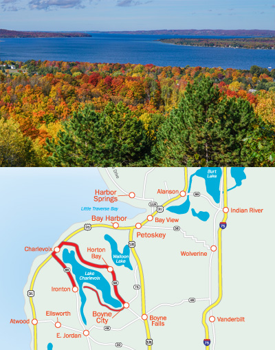
Circle Lake Charlevoix
Route Length: 35 miles
Drive Time: Approx. 50 minutes, plus possible waits for the bridge and ferry
When you get to Mount McSauba Park, stop to explore sandy dunes, hiking trails, and the beach.
Route Start: Depart Boyne City north on Lake Street (C-56) to U.S. 31.
- Turn left at U.S. 31 for about one mile.
- Turn right on Mercer Boulevard and continue to the last street.
- Take a left at the end, then another left.
- Continue on to Mount McSauba Road and turn right at the stop sign. Return to U.S. 31.
- Continue on U.S. 31 straight into town.
- Depart Charlevoix on U.S. South to M-66.
- Take a left into Ironton.
- Turn left and board the Ironton Ferry (nominal fee)
- Continue straight along Ferry Road to Boyne City
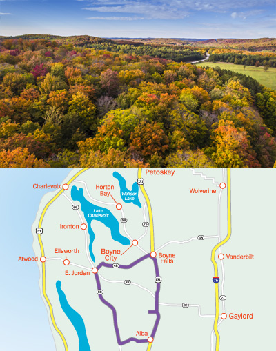
Jordan River Valley Tour
DRoute Length: 50 miles
Drive Time: Approx. 1 hour
Be sure to enjoy the scenic overlooks, including spectacular views of the Jordan River Valley at Deadman’s Hill Overlook just south of Boyne Falls.
Route Start: Depart Boyne Falls west along M-75 one mile to Deer Lake Road (C-48) and bear left. You’ll pass beautiful Deer Lake and also Boyne Mountain’s championship golf courses.
- Stay left on C-48 into East Jordan.
- Turn left at M-66. There’s an overlook with breathtaking vistas and you’ll cross the 45th Parallel.
- Turn left on Alba Road.
- Take a left at the junction of U.S. 131.
- Continue five miles to the Deadman’s Hill turnoff and go left. The view of the Jordan River Valley from Deadman’s Hill is well worth the trip over a bumpy dirt road. (very short walk from the parking area to the overlook)
- Backtrack to U.S. 131, turn left, and return to Boyne Falls.
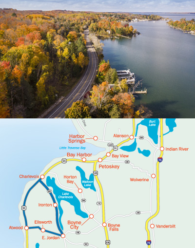
Surf and Turf
Route Length: 35 miles
Drive time: Approx. 45 minutes
Rolling hills, picturesque Michigan farms, and the south arm of Lake Charlevoix are highlights of this tour.
Route Start: Depart Charlevoix along U.S. 31 south to the Ellsworth turn (C-48) at Atwood.
- Turn left on C-48, continue five miles, and turn left on Church, then left again at the next stop, staying on C-48.
- In East Jordan, turn left on M-66 (you’ll pass the Ironton Ferry – highlighted in “Ripley’s Believe It or Not”) on this route.
- Stay on M-66 to U.S. 31. A right on U.S. 31 takes you back into beautiful Charlevoix.
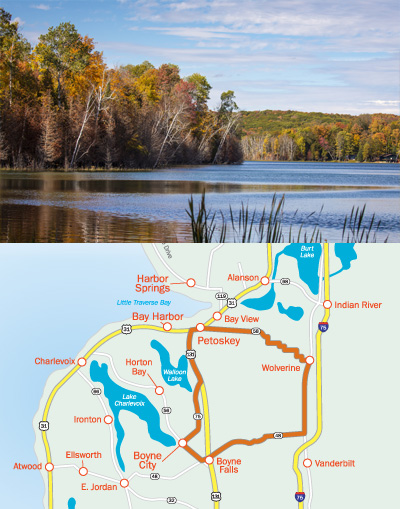
Tri County Tour
Route Length: 62 miles
Drive Time: Approx. 1 1/4 hours
On your return to Petoskey, be sure to take a moment to enjoy the spectacular view as you crest the hill entering town.
Route Start: Head east out of Petoskey on Mitchell Street (C-58), taking note of the beautiful rolling hills and wide open fields; a stop at Bill’s Farm Market is also suggested! You’ll pass Wildwood Road (or turn onto it, if you wish, for hiking and cross-country trails) and continue to Wolverine, home of the Lumberjack Festival.
- Take a right at the stoplight onto Straits Highway, continue for seven miles to Thumb Lake Road (C-48).
- Take a right onto U.S. 131.
- Go left on U.S. 131 to Boyne Falls.
- Turn west on M-75 to lovely Boyne City.
- Stay on M-75 north through Walloon Lake Village to U.S. 131.
- Turn left and return to Petoskey. The gorgeous view on U.S. 131 is a welcoming invitation into a friendly town!
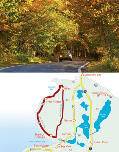
Tunnel of Trees
View a detailed map of the Tunnel of Trees online.
Route Length: 50 miles
Drive Time: Approx. 1 1/4 hours
The scenery on these tours is among the best anywhere. Looking for additional stops along this route? Check out Things to Do Along the Tunnel of Trees
Route Start: Depart Harbor Springs north on M-119 (perhaps investigating the Thorne Swift Nature Preserve and its beach on Lower Shore Drive).
- M-119 takes you through Good Hart, where guests have been visiting the quaint Good Hart General Store since 1934. Next, you’re on to Cross Village and home of Legs Inn (note this is a seasonal property often closing for the season the third week of October), an historical and architectural wonder.
- Continue on M-119 for several miles to the stop sign.
- Turn left on Lake Shore Drive to Lakeview Road at Sturgeon Bay and its sugar-sand beach and dunes.
- Continue on Lakeview, which becomes Gill Road.
- On Gill Road, go three miles to Bliss and the junction with Pleasantview Road (C-81).
- Continue south on Pleasantview Road to M-119.
- Turn right on M-119 to return to Harbor Springs.


